March 2, 2025

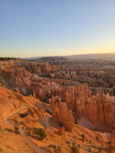
Bryce Canyon National Park may be known as the little brother to Zion. Only about ⅓ the size, cooler temperatures and half as many visitors, this park may sometimes be overlooked. Some even call Bryce a one-trick pony because it lacks the variety of activities that Zion boasts. However, if you add in a bike ride through Bryce Canyon in addition to seeing the famous hoodoos, it’s definitely worth a visit.
With only about 80 miles between them, making the trek from Zion Park to Bryce Canyon is an easy day trip which is exactly what we did. We always jump on the chance to check off more than one national park in a trip. We left Zion super early because we wanted to catch the sunrise over the hoodoos.
I actually enjoyed the sunrise more from Sunset Point instead of Sunrise Point. That being said, I don’t think catching the sunrise was a must do. It was pretty, obviously, and it made getting a parking spot easy, but if you’re driving from Zion I would recommend sleeping in a bit longer. If you’d like to tack on a Zion National Park bike ride as well be sure to check out the post below!
Figure 8 Loop Hike
Bryce Canyon is at a much higher elevation than Zion so the temperatures are quite a bit cooler in the mornings. Because of that, we wanted to wait until later in the afternoon to start our bike ride. We spent the morning hiking through the hoodoos on the Figure 8 Loop. It was spectacular! If you want to experience all that Bryce Canyon has to offer with all the highlights I highly recommend this hike.

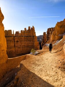
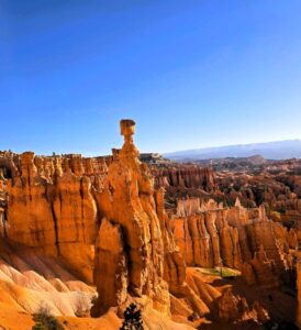
This 6.6 mile hike combines the Queen’s Garden, Navajo Loop and Peekaboo Loop into one stunning hike. Although most recommendations I read beforehand said to start at Sunrise Point and walk in a clockwise direction, we started at Sunset Point instead. We descended on the Navajo Loop first which takes you right by Thor’s Hammer. The famous Wall Street path was closed (until memorial day usually) so we had to take the Two Bridges side of the loop instead. I was disappointed at first, but I was so wrong!
The Two Bridges Trail was gorgeous and had it’s own set of steep switchbacks, similar to Wall Street, that offered great pictures. After about one mile, you’ll run into the Peekaboo connector path which is not well marked. The path is a little faded, but just keep walking straight until you reach a trail sign. Here we went left first, finished the loop, walked back along the connector path and took a right towards Queen’s Garden.
The trail is forest covered for a while until it opens back up to the more desert landscape and the hoodoos. At the end of the trail there is a very steep uphill climb to make it back up to Sunrise Point. This is probably why people recommend to walk it the other direction. After making it to the top, follow the 0.5 mile paved trail back to the parking lot at Sunset Point.
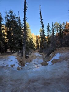
The majority of the hike is fairly flat or moderate inclines. There are more rolling hills on the Peekaboo Loop side, where it does get steep at times. During the spring there is often snow and ice still on the trail so use caution in these sections. There is a bathroom at the halfway point on the Peekaboo Loop.
The bonus to starting the hike early and on the Sunset Point side? You have the trail all to yourself. It was easy to get pictures of everything without any people in the background. We only passed two people during the entire Peekaboo Loop. By the time we were ascending to Sunrise Point, traffic on the easy Queen’s Garden Trail had picked up.
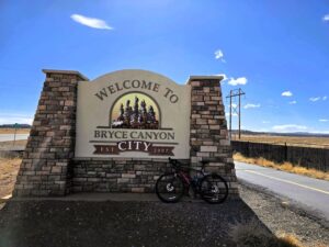
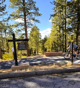
By this time, after a quick sandwich in the car, it was warm enough to start the bike ride. We decided to drive to the trailhead and then ride back towards the park. This way we end on a long downhill, instead of finishing with a climb. We drove the 16 miles to Thunder Mountain Trailhead which has a nice parking lot on the left side of the road and the start of the paved Canyon Bike Trail.
biking to Bryce Canyon
Mentally prepare yourself because the start is about 6 miles of pretty steep climbing. I had to stop multiple times after hills to catch my breath. The majority of this 18 miles ride is uphill, but if you want to skip the worst part, park instead at the Red Canyon trail access lot to cut off the worst 6 miles of climbing.
Then about 6 miles of mostly flat trail awaits you through the open sagebrush flats. Not gonna lie, this section of trail felt never-ending on the ride back. The trail in these miles is pretty bumpy and filled with fairly deep cracks. This is not a sight you want to see when your butt is sore from multiple days of riding!
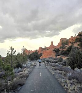
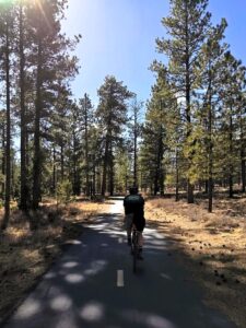
About 11.5 miles in, continue to follow the Canyon Bike Trail as it curves to the right, past Subway, as it now follows Highway 63. It’s then about 1.5 miles into Bryce City where the bike trail momentarily ends. Bike on the shoulder of the road until you get to the traffic light by Ruby’s Inn. Here you can cross the street and ride through the parking lots of the western themed shops. After 0.3 miles, you’ll run into the start of the Multi-Use Path at the parking lot of the Bryce Canyon Shuttle. This 5-mile long trail will take you all the way to Lower Inspiration Point.
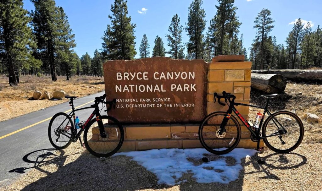
This path is beautifully paved and meanders through the woods far enough away from the main road that it feels secluded. The bad news? The ride is STILL UPHILL! You’ll gain nearly 1,500 feet in elevation over the 18 mile ride. The good news? There’s a little surprise only 1-mile into the Multi-Use Path to break up the climb.
There is a Bryce Canyon National Park sign exclusive to the bike trail! It’s a perfect, smaller version of the main road sign and of course offers a perfect photo stop. It was fantastic because we didn’t have to bike the main road to make it to the sign or wait in line for a picture. Definitely take advantage!
At the halfway point, you’ll ride straight through the Visitor Center parking lot. This is a great stop for a bathroom break, water bottle fill, snack or of course a souvenir. At the 4 mile mark you’ll reach Sunset Point, which is home to the trailhead for the Navajo Loop. I was definitely ready to call it quits by this point, but we rallied on for the last mile and it was worth it.
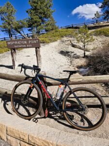
The trail ends at the parking lot for Lower Inspiration Point which boasts the best view of the Silent City, a densely packed collection of hoodoos. My legs did not want me to hike to Upper Inspiration Point, but the views here were amazing. There are bike racks all over the park so that made it easy to stop at all the viewpoints.
The 18 miles back to the Thunder Mountain Trailhead definitely went a lot quicker than the climb up, especially the 5 miles on the Multi-Use Path. There was one large uphill on the way back just after the Visitor Center. We were outrunning a thunderstorm so that was some extra motivation as well.
Overall, it was a great way to truly experience Bryce Canyon. The park’s forest landscape hides the hoodoos unless you make it to the lookout parking lots. By adding the biking, you get to extend the magic of the park, just be ready to climb!